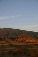
November 3rd, 2005: Taxco, Mexico to Teotihuacan, Mexico
November 4th, 2005: Teotihuacan, Mexico to Puebla, Mexico
 Our drive to Teotihuacan took us through downtown Mexico City. Battling the traffic there is unbelievable. It makes rush hour in Toronto seem like a walk in the park. There are so
 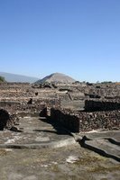 many cars on the road, that you are only granted permits to drive on certain days of the week, and even then it is total gridlock. I can assure you, that the only thing worse than being stuck in rush hour traffic in Mexico City, is being stuck in rush hour traffic in Mexico City behind a truck full of animal parts rotting in 30 degree sun. And, I suppose, as well, the only thing worse than seeing a truck full of stinking animal parts, is worrying that it's going to end up in your next burrito. After battling that traffic for a good while, we finally got on a less travelled route to
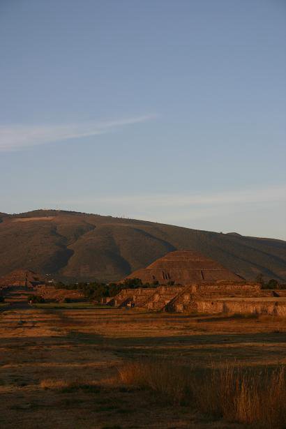
  Teotihuacan and ended up stumbling upon a Club Med. We went to Teotihuacan to see the Pyramide Del Sol and the Pyramide De Lun (Pyramid of the Sun and Pyramid of the Moon, respectively). We woke up to a VERY chilly morning. There was even frost on the bikes! We were pretty shocked that it was that chilly,
 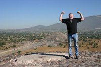 but it appears the Mexicans found it even worse. When we left the gate of the hotel the men were wearing jackets, and at the entrance to the Pyramids the man was bundled up in a thick jacket and had winter gloves on! The Pyramide Del Sol is apparently even taller than the pyramids in Egypt, and you are able to climb right to the top of it. We had to take a few breathers on the way, but we made it to the top, and of course had to do the "victorious flexing of the muscles" pose. Two seconds after taking the picture a busload of school kids came bounding up the steps in one shot. Thank goodness we got our victory shots in before they came along, or we
  might have gotten a few laughs. From the top of the pyramids you could see the entire archeological site, and all of the valley between the mountains. Unfortunately, it also gives you a great view of the yellow blanket of smog over Mexico City. It wasn't so chilly after hiking up a pyramid, but due to the cold weather we both forgot sunscreen and now we look permanently embarassed. After heading back from the pyramids we made the drive from Teotihuacan to Puebla. It was pretty chilly again for some parts of the drive. Overall the temperature is nice and warm during the day, but in some
  areas it gets colder due to the altitude. In fact, on our drive to Puebla there are snow capped mountains!!! Who'd have thought that'd we'd see snow here before there was snow in Canada! Puebla is a very nice city, and oddly enough, looks almost more European than Mexican. We visited the Institute of Culture (from what I gather, it's like an arts college). It looks just like a castle from the outside, and when we got inside, Jan realized that it used to be a jail. The architecture here is beautiful and there are many old buildings, fountains, and statues around the city.
November 4th, 2005: Teotihuacan, Mexico to Puebla, Mexico
 Our drive to Teotihuacan took us through downtown Mexico City. Battling the traffic there is unbelievable. It makes rush hour in Toronto seem like a walk in the park. There are so
  many cars on the road, that you are only granted permits to drive on certain days of the week, and even then it is total gridlock. I can assure you, that the only thing worse than being stuck in rush hour traffic in Mexico City, is being stuck in rush hour traffic in Mexico City behind a truck full of animal parts rotting in 30 degree sun. And, I suppose, as well, the only thing worse than seeing a truck full of stinking animal parts, is worrying that it's going to end up in your next burrito. After battling that traffic for a good while, we finally got on a less travelled route to
  Teotihuacan and ended up stumbling upon a Club Med. We went to Teotihuacan to see the Pyramide Del Sol and the Pyramide De Lun (Pyramid of the Sun and Pyramid of the Moon, respectively). We woke up to a VERY chilly morning. There was even frost on the bikes! We were pretty shocked that it was that chilly,
  but it appears the Mexicans found it even worse. When we left the gate of the hotel the men were wearing jackets, and at the entrance to the Pyramids the man was bundled up in a thick jacket and had winter gloves on! The Pyramide Del Sol is apparently even taller than the pyramids in Egypt, and you are able to climb right to the top of it. We had to take a few breathers on the way, but we made it to the top, and of course had to do the "victorious flexing of the muscles" pose. Two seconds after taking the picture a busload of school kids came bounding up the steps in one shot. Thank goodness we got our victory shots in before they came along, or we
 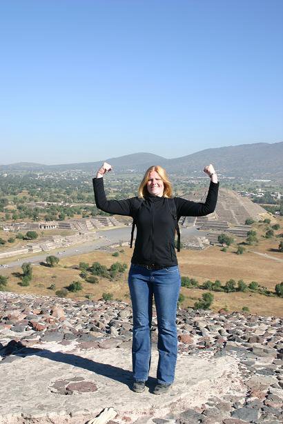 might have gotten a few laughs. From the top of the pyramids you could see the entire archeological site, and all of the valley between the mountains. Unfortunately, it also gives you a great view of the yellow blanket of smog over Mexico City. It wasn't so chilly after hiking up a pyramid, but due to the cold weather we both forgot sunscreen and now we look permanently embarassed. After heading back from the pyramids we made the drive from Teotihuacan to Puebla. It was pretty chilly again for some parts of the drive. Overall the temperature is nice and warm during the day, but in some
  areas it gets colder due to the altitude. In fact, on our drive to Puebla there are snow capped mountains!!! Who'd have thought that'd we'd see snow here before there was snow in Canada! Puebla is a very nice city, and oddly enough, looks almost more European than Mexican. We visited the Institute of Culture (from what I gather, it's like an arts college). It looks just like a castle from the outside, and when we got inside, Jan realized that it used to be a jail. The architecture here is beautiful and there are many old buildings, fountains, and statues around the city.
No comments:
Post a Comment